publications
publications by categories in reversed chronological order. generated by jekyll-scholar.
2026
-
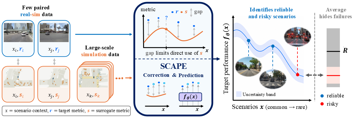 SCAPE: Scenario-Conditioned Simulation-Augmented Policy EvaluationDijie Zhu*, Seunghun Oh, Ruopeng Huang, and 3 more authorsConference on Robot Learning (CoRL), 2026
Reliable performance evaluation is a central bottleneck for deploying robot-learning policies in real-world conditions. Real-world testing produces faithful evaluation but is costly and difficult to scale, whereas simulation-based testing is easy to scale but inevitably biased due to the sim-to-real gap. Neither source alone is sufficient for scalable and reliable policy evaluation. This motivates simulation-augmented policy evaluation, which combines limited real-world rollouts with abundant simulation proxies for sample-efficient performance estimation. Yet, existing methods focus on estimating performance averaged over initial conditions and deployment settings. By construction, such population-level averages collapse scenario-specific variation, providing limited information about when and where a policy can be safely deployed. To address this limitation, we propose SCAPE, a scenario-conditioned simulation-augmented policy evaluation framework that instead predicts scenario-conditioned real-world policy performance from limited paired sim-and-real evaluation samples and large-scale simulation-based testing rollouts. SCAPE corrects the sim-to-real bias in the simulation labels before using them to train the prediction model, and calibrates the prediction uncertainty through conformal prediction. We validate SCAPE on two embodied task domains, autonomous driving and quadruped velocity tracking. In sim-to-sim settings, it reduces the scenario-level performance prediction error by 4.9%/34.7% (driving) and 14.5%/27.7% (quadruped) relative to scene-conditioned neural baselines and aggregate statistical baselines on average. We also validate SCAPE for evaluating a velocity-tracking policy deployed on a physical Unitree Go2. In addition, SCAPE improves testing sample-efficiency, produces narrower calibrated prediction intervals, enhances generalization to out-of-distribution scenarios, and unlocks fine-grained deployment strategies.
-
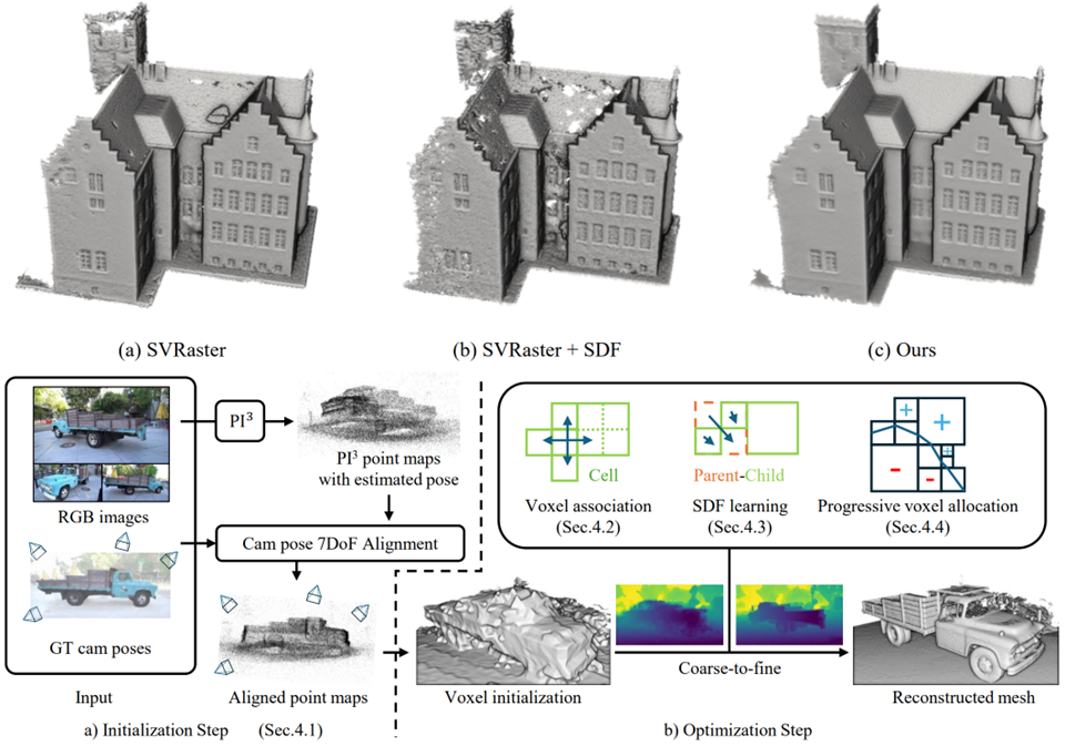 SVRecon: Sparse Voxel Rasterization for Surface ReconstructionSeunghun Oh*, Jaesung Choe, Dongjae Lee, and 4 more authorsPreprint, arXiv, 2026
We extend the recently proposed sparse voxel rasterization paradigm to the task of high-fidelity surface reconstruction by integrating Signed Distance Function (SDF), named SVRecon. Unlike 3D Gaussians, sparse voxels are spatially disentangled from their neighbors and have sharp boundaries, which makes them prone to local minima during optimization. Although SDF values provide a naturally smooth and continuous geometric field, preserving this smoothness across independently parameterized sparse voxels is nontrivial. To address this challenge, we promote coherent and smooth voxel-wise structure through (1) robust geometric initialization using a visual geometry model and (2) a spatial smoothness loss that enforces coherent relationships across parent-child and sibling voxel groups. Extensive experiments across various benchmarks show that our method achieves strong reconstruction accuracy while having consistently speedy convergence. The code will be made public.
-
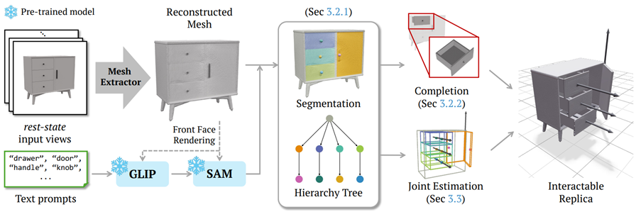 Articulated Furniture Recovery from Rest-State Multi-View ImagesDaeun Lee*, Jaeah Lee, Woosung Kim, and 2 more authorsPreprint, 2026
Digital twins require fully interactive replicas that capture both 3D geometry and articulated structures so that objects can be manipulated as in real life. While recent methods have advanced articulated object reconstruction by incorporating part-wise geometry and joint parameters, they often rely on restrictive input conditions, such as multiple articulation states or prior knowledge of part counts, thereby limiting practical applicability. To overcome these constraints, we propose a rest-state formulation that reconstructs articulated objects such as furniture from multi-view images of a single rest state, where all parts remain closed. Our pipeline begins by reconstructing a surface mesh, then performs 3D functional segmentation of openable objects with uniform or repetitive geometries by leveraging 2D foundation models. It subsequently converts the incomplete surface mesh into closed, watertight part meshes through solidification and amodal shape blending. Finally, we estimate joint parameters by integrating geometric, semantic, and physical constraints to achieve realistic articulation. Our experiments demonstrate that our rest-state approach achieves high-quality reconstructions and accurate articulation results without requiring multiple articulation states or part annotations.
2025
-
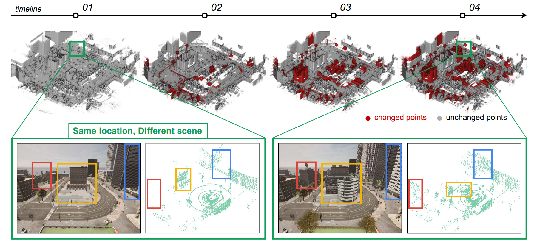 The City that Never Settles: Simulation-based LiDAR Dataset for Long-Term Place Recognition Under Extreme Structural ChangesHyunho Song*, Dongjae Lee, Seunghun Oh, and 2 more authorsICRA 2025 Workshop on Future of Construction, 2025Best Paper Award
Large-scale construction and demolition significantly challenge long-term place recognition (PR) by drastically reshaping urban and suburban environments. Existing datasets predominantly reflect limited or indoor-focused changes, failing to adequately represent extensive outdoor transformations. To bridge this gap, we introduce the City that Never Settles (CNS) dataset, a simulation-based dataset created using the CARLA simulator, capturing major structural changes-such as building construction and demolition-across diverse maps and sequences. Additionally, we propose TCR_sym, a symmetric version of the original TCR metric, enabling consistent measurement of structural changes irrespective of source-target ordering. Quantitative comparisons demonstrate that CNS encompasses more extensive transformations than current real-world benchmarks. Evaluations of state-of-the-art LiDAR-based PR methods on CNS reveal substantial performance degradation, underscoring the need for robust algorithms capable of handling significant environmental changes.
-
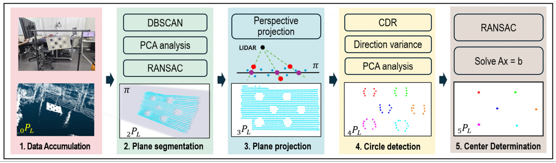 LiDAR Data Processing Algorithm for Robust 6-DoF Estimation Using Circular PatternsSeunghun Oh*, Yechan Kim*, Chaehyeon Song, and 1 more authorThe Journal of Korea Robotics Society(KROS), 2025
Accurate LiDAR (Light Detection and Ranging) data processing is essential for precise sensor calibration and reliable 3D perception in applications such as autonomous driving and robotics. Traditional methods often rely on artificial targets like circular patterns for 6-DoF estimation due to their ability to precisely detect geometric features. However, few studies focus on improving the accuracy of raw LiDAR data through preprocessing, leaving unresolved issues related to LiDAR’s inherent limitations. To address these challenges, we propose a novel LiDAR data processing algorithm that improves robustness and 6-DoF estimation accuracy. It enhances target plane detection accuracy by using perspective projection, accounting for LiDAR’s range direction errors. We also resolve data bias from scanning patterns using CDR (Centroid Distance Ratio) and directional variance, allowing for the extraction of reliable boundary points. Experimental results demonstrate significantly lower RMSE compared to existing techniques, highlighting the enhanced precision and robustness of our approach. Furthermore, our method achieves higher accuracy in 6-DoF estimation compared to traditional methods.
2024
-
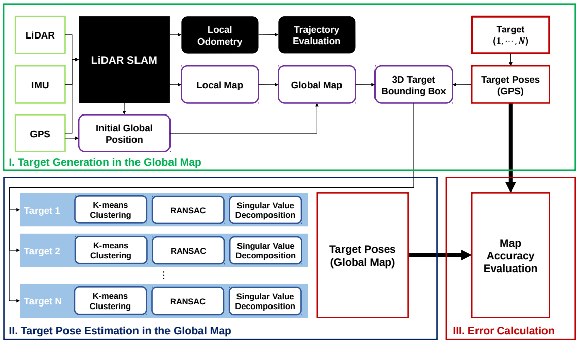 Quantitative 3D Map Accuracy Evaluation Hardware and Algorithm for LiDAR (-Inertial) SLAMSanghyun Hahn*, Seunghun Oh*, Minwoo Jung, and 2 more authorsIn 2024 24th International Conference on Control, Automation and Systems (ICCAS), 2024
Accuracy evaluation of a 3D pointcloud map is crucial for the development of autonomous driving systems. In this work, we propose a user-independent software/hardware system that can quantitatively evaluate the accuracy of a 3D pointcloud map acquired from LiDAR(-Inertial) SLAM. We introduce a LiDAR target that functions robustly in the outdoor environment, while remaining observable by LiDAR. We also propose a software algorithm that automatically extracts representative points and calculates the accuracy of the 3D pointcloud map by leveraging GPS position data. This methodology overcomes the limitations of the manual selection method, that its result varies between users. Furthermore, two different error metrics, relative and absolute errors, are introduced to analyze the accuracy from different perspectives.